06/18/2025.
The Newark Valley is truly the Valley of the Moon. Let me try to make the case for that.
Let me also add that, if the Lenape, who named so many rivers in the area, including the Licking (with its characteristic "-ing" as a locative suffix), had been aware of the significance of the Earthworks, they quite likely have named this area Nipahaming. Nipaham was one of their older names for the moon: The Night Voyager.
I don't know if anybody (recently!) noticed this before, but, completely by coincidence, the Newark Valley aligns with the northernmost moonrise and northernmost moonset, which happen at the Major Standstill.
The azimuths I am using here are 51.8° and -51.8° (that is, 38.2° north of east for the moonrise and 38.2° north of west for the moonset). As is well-known, the maximum rises and sets are symmetric around a north/south axis. That 38.2° that I am using is read from the Octagon itself. There is some question about whether to use the upper or lower limb of the moon to define the rises/sets, or the center, and whether to include distant topographical elevations. I ignore all that and say, this is the angle that the Indigenous Peoples of the Hopewell Culture considered important regarding the moonrise, because that is what they used to orient the Octagon.
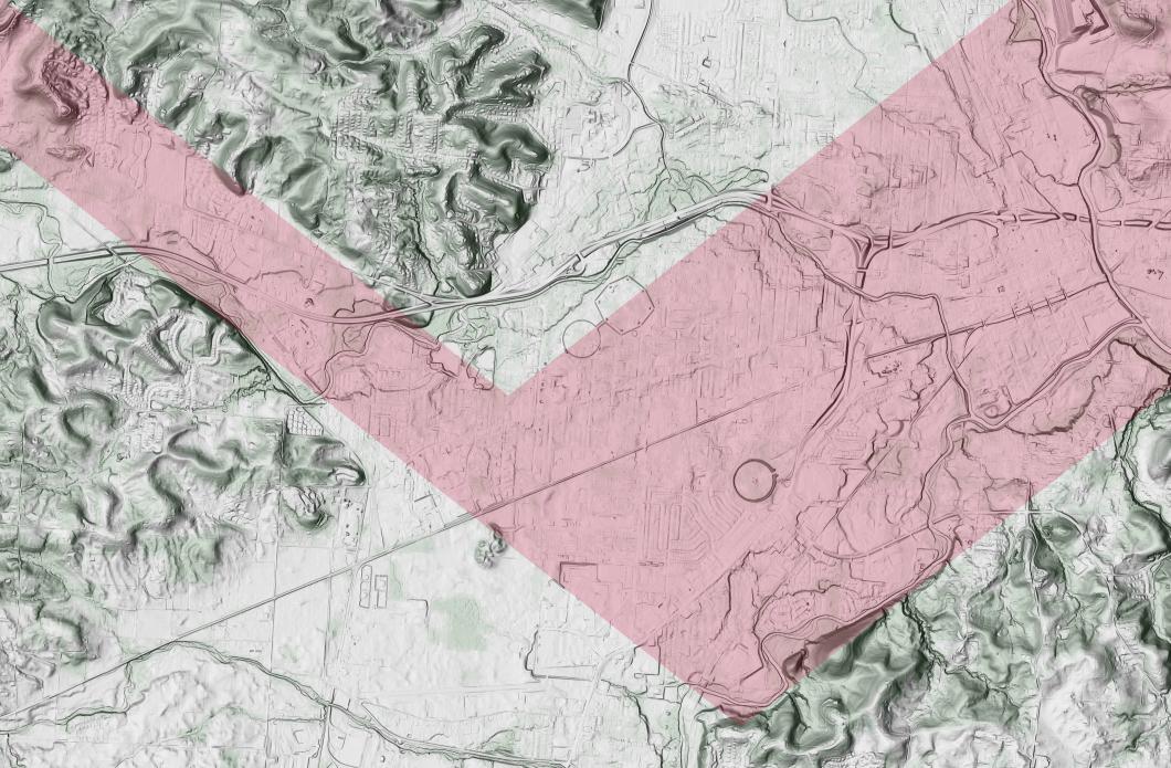
The lower moonrise leg of the "V" is defined by Salisbury Hill, a natural feature, which naturally points to the northernmost rise. I've discussed this before. (See Up On Salisbury Hill.) The upper moonrise leg of the "V" is defined by the axis of the Octagon itelf.
The moonset legs are found by reflecting the moonrise direction about a north/south axis. One starts atop Salisbury Hill; the other starts from the highest point on Geller Hill.
This is the way the Indigenous Peoples found the "V"alley. Part of their genius would have been in recognizing the way the topography of the area aligns with the moon.
When looking at earthworks, it's not all that clear that Raccoon Valley (the west leg of the "V") aligns with the northernmost moonset. After all, the map "Six Miles of the Newark Valley", by Squier and Davis, in Ancient Monuments of the Mississippi Valley (Smithsonian Contributions to Knowledge, No. 1, 1847) does not have a directional arrow, but makes the valley appear to run east/west.
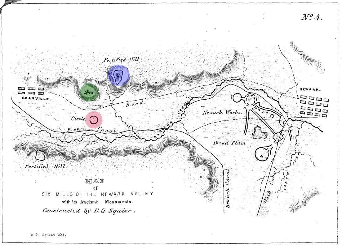
It does not.
We know where the Heart of Granville was (highlighted in blue), since some of it still shows up on LiDAR. We know where the Alligator Mound (green) is, since it has been preserved.
Little to nothing remains of the Granville Circle (red).
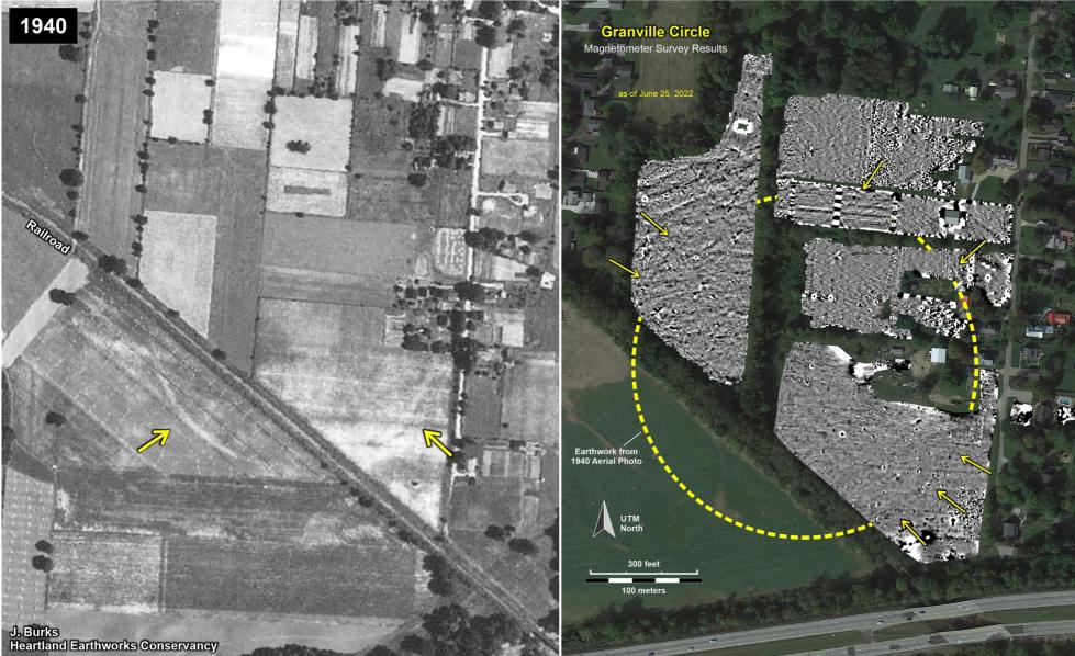
However, we know almost exactly where the Granville Circle was, and how big it was, due to the efforts of people like Jarrod Burks (who runs magnetometer surveys) and David Lamp (who scours old aerial photos), with assistance from people like Al Tonetti. They do so under the auspices of the Heartland Earthworks Conservancy.
On the left is an old aerial photograph, and on the right is the result of a magnetometer survey via Jarrod and Al (and others).
There is another map, in the book "History of Granville", by Henry Bushnell (1889).
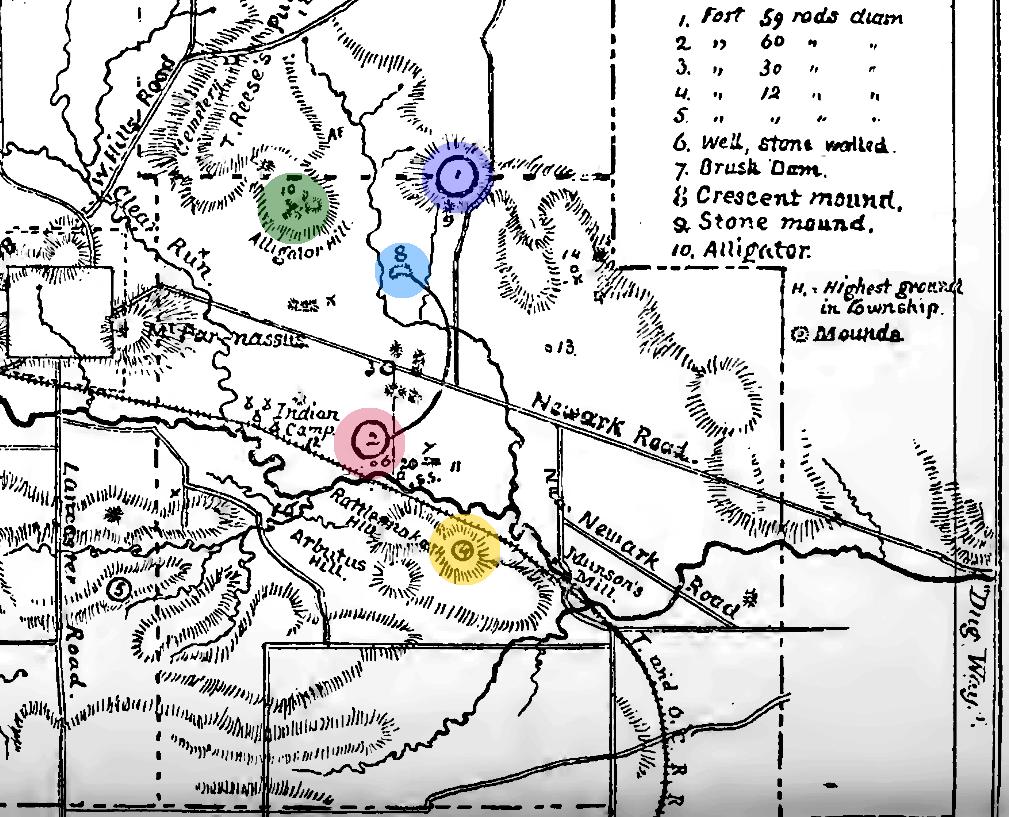
It does a better job of portraying the angle of Raccoon Valley. The angle of Newark-Granville road is nearly spot-on, though the railroad to the south (now the T. J. Evans Multi-use Trail) is off by about 10°.
He shows the Heart of Granville, Alligator Mound, and the Granville Circle (highlighted in the same colors as before). But also of note is the hilltop enclosure atop Rattlesnake Hill (orange) and the Crescent between them all (light blue). Bushnell gives a description that helps to locate them:
"Between these two spurs (the Heart of Granville and Alligator Mound), and about equally distant from each of them, but sixty or eighty rods further south, the ground around being valley loam, lies an elevation formed of gravel, in the shape of a crescent, its points opening toward the south and a little west. It is about ten rods from tip to tip, and six rods across from exterior to interior curve.
"From the eastern side of the crescent a parapet starts off, sweeping eastward and southward in a semicircle to a point half a mile south of the crescent, where it connects with a circular fort (Granville Circle), which is about 980 feet in diameter and contains over seventeen acres.
"Midway between the crescent and the large fort with which it is joined by the semicircle, is a smaller circular fort, containing about eight acres. The Centerville street (Newark-Granville Rd.) has always run through it just north of its center, and the road to the old-time factory started just at its eastern side."
I've updated a shaded relief map to show these features.
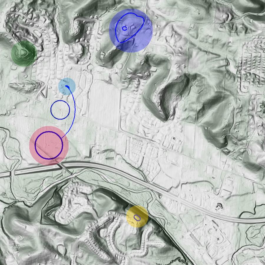
The Heart of Granville, Alligator Mound, and the Granville Circle are accurately placed. The location of Rattlesnake Hill is a bit dubious, since that area is now covered by a subdivision, and who knows what sort of grading was done. When it comes to the railroad, obviously some hillside was disturbed to place it, but I've bicycled that trail many times, and it does not look like anything was particularly moved. The issue is (mostly) how far from that steep slope the enclosure was. There are two reasonable high points (or hilltops) there; I've chosen the more northerly, partly with malice aforethought, for later in this post.
With additional malice aforethought, I've placed the crescent (facing somewhat west of due south), parapet, and the smaller circle northwest of Granville Circle. As stated, the smaller circle intersects Newark-Granville road. While I cannot claim complete accuracy, I can state that these locations are not in disagreement with the description.
I have color-coded all of those earthworks the same as before, while adding light blue for the crescent.
[I warn about "malice aforethought"—these locations make the alignments more impressive. But people ought to be warned that in each case I have taken the more advantageous choice, and should discount them as they see fit.]
Now let me add two of my 38.2° moonset lines.
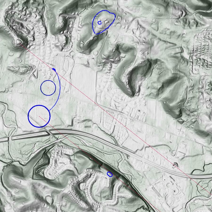
The first one I've shown before: it runs between Salisbury's Hill Fort #2 and Alligator Mound, quite precisely. (See Chimney Rock.) The other, new to me, runs between the now-located Granville Circle and passes over Rattlesnake Hill.
Again, "malice aforethought" placed the crescent, and I chose the more interesting hilltop for the Rattlesnake Hill enclosure.
This now gets very interesting. The line that passes through Granville Circle passes very close to the highest point on Geller Hill.
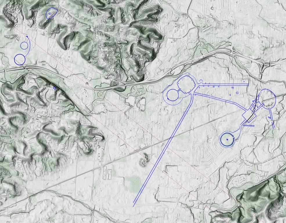
Even though neither one is within sight of each other, Granville Circle lines up with the northernmost moonset as observed from Geller Hill.
It was certainly within the capabilities of the Indigenous Peoples to have done this deliberately. Using the line of sight from Salisbury's Hill Fort #2, what they would have to have done was create a perpendicular off that line-of-sight to Geller Hill, measured that distance, and then drawn another perpendicular with that distance on the other side of Rattlesnake Hill. It seems to me a subtle recognition of the continuity of the moonset?
Returning to Geller Hill, don't forget that it has other special significance. William Romain (Romain 2005) first pointed out that the high point on Geller Hill is equidistant from the center of the Octagon and the center of the Great Circle. You can see that by bisecting the chord between the Octagon and Great Circle and drawing a perpendicular (orange).
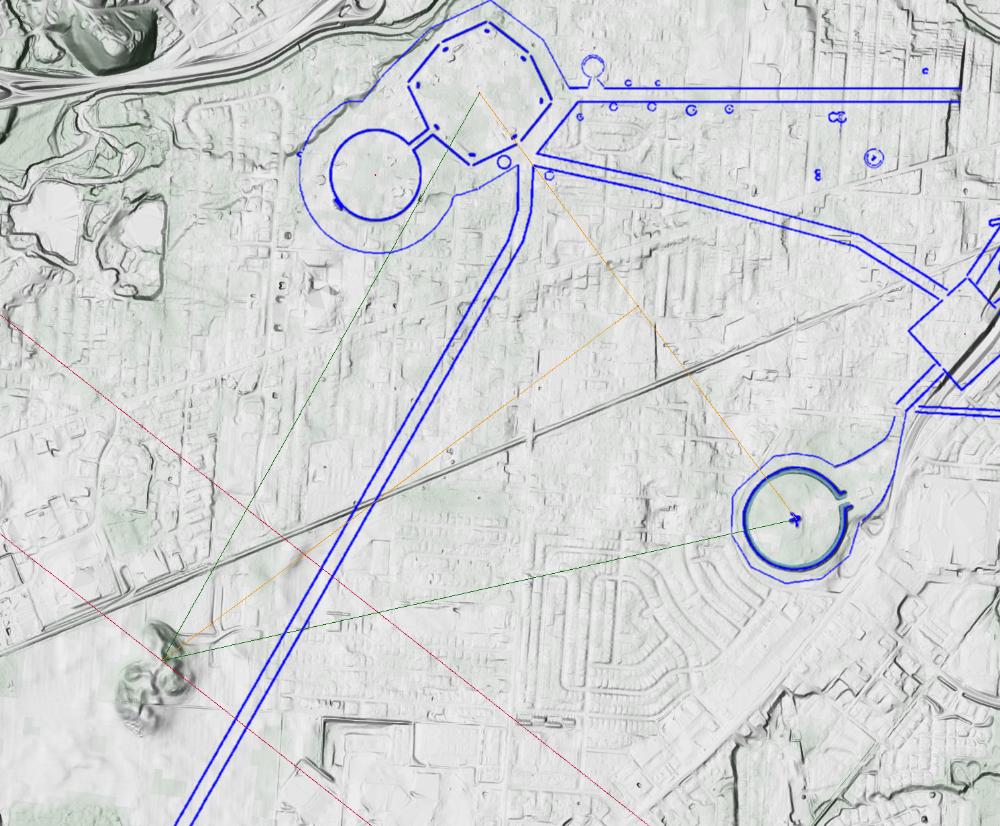
Anything on that perpendicular line is equidistance from the two, and we can see those two equidistant lines (green) atop Geller Hill.
I've also seen other people pooh-poohing the idea, despite touting the fact that the distance from the center of Observatory Circle and the center of the Great Circle is the same distance as the one between the center of the Octagon and the center of Wright Square.
Anyways, in that picture, we can also see how the moonset line also comes in atop Geller Hill. (It's not perfectly at the high point, but extraordinarily close.)
So, what would the Indigenous Peoples see looking up Raccoon Valley from atop Geller Hill? This picture shows a northernmost moonset.
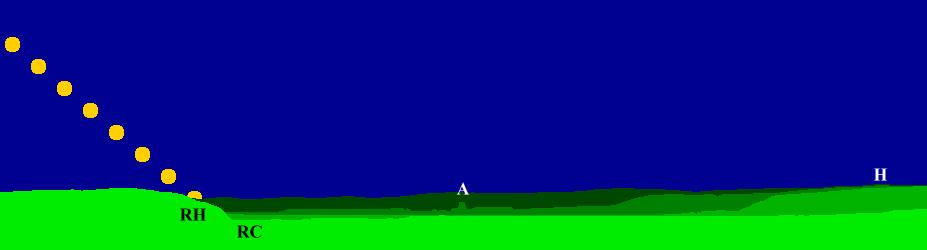
The darker the green, the more distant the horizon. The darkest green is 4 to 5 miles away. The really bright green, which is along the side hills of the valley and include Rattlesnake Hill, is about 2 miles. The middling greens on the right show the valley closing in on its northern side as it heads up the valley.
"H" shows where the Heart of Granville just pokes up. "RC" is the bottomland for Raccoon Creek and "RH" is Rattlesnake Hill. In the middle there, "A" is the location of Alligator Mound, which sits on that promontory that sticks out looking down the valley. I think it's really cool the way it shows up here.
The picture also shows the northernmost moonset on March 28 in the year 201. (Note that northernmost moonsets occur at night during the spring. The moon should be a 1st quarter moon, not a full moon as I have shown.)
Here's a closer view of that moonset.
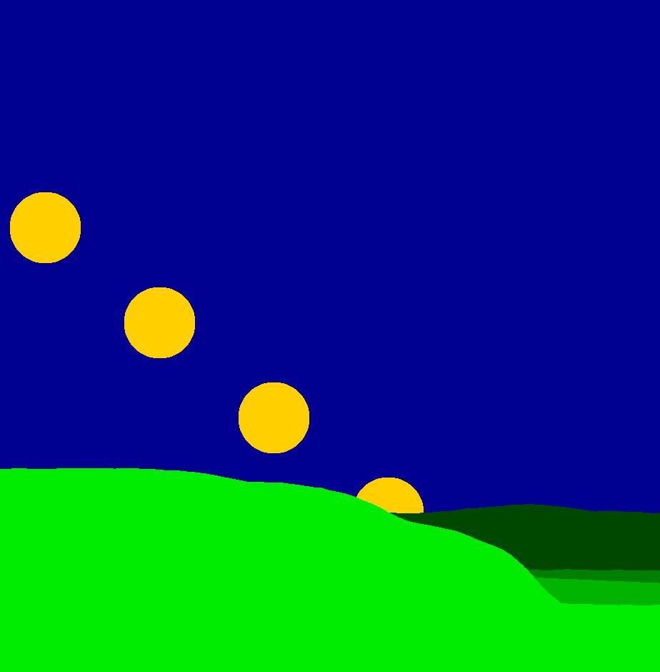
You can see that the moon comes down right at the location that the near hills give way to the distant horizon. Of course, that varies depending on where one stands on Geller Hill, but the effect would nonetheless be pretty impressive.
At this point, I again need to remind folks of a major caveat. The picture uses treeless hills and horizons. We do not know just what was visible. We know that it was prairie around the Great Circle. (Lepper 1996) We also know that the top of Fort Ancient had been cleared (McLauchlan 2003), so I guess it is not unreasonable to think that all of the hilltop enclosures had also been cleared.
Thus, for instance, there would have been a clear view from Salisbury Hill Fort #2 to the promontory where Alligator Mound now sits. Any campfire atop atop Alligator Hill would have been easily visible.
Before wrapping this up, I'd like to add one more . . . effect? . . . feature? . . . coincidence?
Another ancient topographical feature of the area is that the path between the Newark (Licking River and Raccoon Creek) Valley and the Scioto/Paint Creek Valley runs along the "nebulous" path of the Milky Way at or around the summer solstice. That's the path of the Great Hopewell Road. It has also been pointed out (again, if I remember correctly, by William Romain (Romain 2015)) that this path is perpendicular to the summer solstice sunset (or looking the other direction, perpendicular to the winter solstice sunrise).
As we can see in the picture, if we take that perpendicular, it runs from the top of Salisbury Hill to Granville Circle.
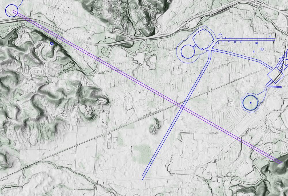
If one were concerned with memorializing the summer solstice sunset from Salisbury Hill and the northernmost moonset from Geller Hill, Granville Circle is that intersection.
If you go to Salisbury Hill this Saturday, you can watch the sun set at where Granville Circle used to be.
It is my suspicion that this area was the terminus of pilgrimages long before the Hopewell Ceremonial Earthworks (or Great Hopewell Road) were constructed.
The way that Salisbury Hill points to the northernmost moonrise; the way that Raccoon Creek Valley is edged to point at the northernmost moonset, using the placements of Geller Hill and Salisbury Hill; and the Milky Way/Solstices path between the Newark Valley and the Scioto/Paint Creek Valley are all ancient properties of the landscape, there since around the time of the retreat of the Wisconsinan glaciers. The Indigenous Peoples took them as they found them.
But it was part of their genius to be able to recognize that about the world around them, and to incorporate that recognition into additional constructions.
In this picture let me put together all these memorializations that I've talked about.
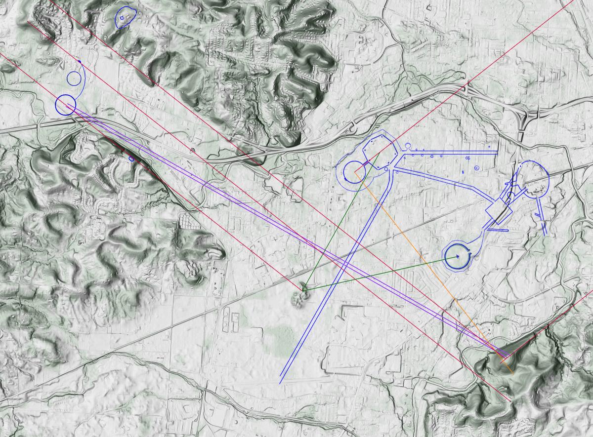
- Blue: Earthworks.
- Green: Distances from Geller Hill to Octagon and Great Circle are the same.
- Red: Northernmost moonrises and northermost moonsets, which are reflections of each other through a north/south axis. The moonrises are the Octagon complex and Salisbury Hill (a natural feature). The moonsets run from Geller Hill towards Rattlesnake Hill along the southwest edge of Raccoon Valley and behind to Granville Circle; from the top of Salisbury Hill along the northeast edge of Raccoon Valley; and from Salisbury Hill Fort #2 to the Alligator Mound promontory (the selection of that particular minor high spot is particularly noteworthy).
- Orange: Perpendicular to the northernmost moonrise at the center of Observatory Circle and ending atop Salisbury Hill. This is also the orientation of the other Octagon (High Bank) to the south at Chillicothe.
- Purple: Summer solstice sunset, perpendicular to the Great Hopewell Road.
While the Newark Valley came with the northermost lunar motions "pre-loaded" by its topography, the Indigenous People truly engineered it, step by step, into the Valley of the Moon.
References:
Lepper 1996.
The Newark Earthworks and the Geometric Enclosures of the Scioto Valley: Connections and Conjectures, p. 233, by Bradley T. Lepper. In A View from the Core: A Synthesis of Ohio Hopewell Archaeology, ed. Paul J. Pacheco. The Ohio Archaeological Council, Inc., Cincinnati (1996).
McLauchlan 2003.
Plant cultivation and forest clearance by prehistoric North Americans: pollen evidence from Fort Ancient, Ohio, USA, Design and Layout of the Newark Earthwork Complex, by Kendra McLauchlan. The Holocene, 13,4 (2003), pp. 557-566.
Romain 2005.
Design and Layout of the Newark Earthwork Complex, by William F. Romain. Hopewell Archeology, Vol. 6, No. 2, March 2005.
Romain 2015.
Adena-Hopewell Earthworks and the Milky Way Path of Souls, by William F. Romain. In Tracing the Relational: The Archaeology of Worlds, Spirits, and Temporalities, ed. Meghan E. Buchanan and B. Jacon Skousen, pp. 54-82. University of Utah Press, Salt Lake City (2015).