03/27/2025.
Today I thought I'd write about Chimney Rock. It's one of the other Major Standstill moonrise sites in the U.S.. Chimney Rock is located in southern Colorado, about 90 miles east-northeast of Chaco Canyon, which it is associated with. It was inhabited around 1,000 years ago.
First, I'm going to write about the Standstill lunistice moonrises there, and then I'll move on to describing the amazing circumstances around it.
Hat tip: Marti Chaatsmith.
Just like the Newark Octagon, Chimney Rock is observing the Major Standstill moonrises. They have been assisted by the Griffith Observatory (in Los Angeles) in that effort. It's way beyond anything being done around here.
This is a composite picture, showing the September 24, 2024 and the October 21, 2024 northernmost lunistice moonrises.
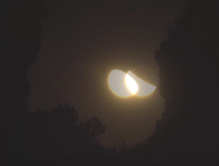
What I did to create it was take two screenshots from the Observatory's two moonrise videos, and then overlay them. Fortunately, it appears that they have a fixed location for their camera, since the pictures lined up perfectly. I will link to those videos in the first two comments here.
There is a lot to unpack.
Obviously it was night-time, so you have to look carefully. On the right side you can see Chimney Rock, which sits (mostly) upright . . . like a chimney. On its left you can see its companion, called Companion Rock. (Duh.) During the Major Standstill lunistice moonrises, the moon rises in that gap between the two.
The moon on the right rose on September 24. Note that it is (just past) a 3rd quarter moon. The moon on the left rose on October 21. You can see it is getting closer to becoming a full moon.
This is the general pattern. Northernmost lunistice moonrises in July are a thin crescent. As they approach December, they get fuller and fuller until the December northernmost lunistice is a Full Moon.
Also note the movement. The October moon rose 0.2° farther to the north (left) than the September moon (because it hit the exact peak of the moon's orbit better), which is why there is a double image. But I think this shows that I am not too far off when I claim that the various Indigenous Peoples would be able to notice that (spring/fall) equinox lunistice moonrises are generally 0.5° farther north than (summer/winter) solstice lunistice moonrises. This is enough of a difference to be seen.
I'd also like to point out that there are no viewings at Chimney Rock from January to June. As I've noted before, that time of year has only day-time moonrises, and by the time the moon has risen high enough to be seen, it is either behind or outside of the two Rocks. The Newark Earthworks are not limited in this regard.
This is a day-time picture of Chimney Rock (right) and Companion Rock (left).
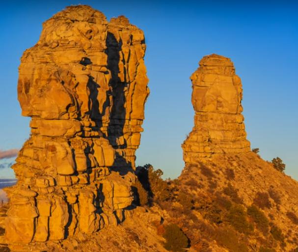
You can even see how well even the bushes/trees showed up in the first picture. Again, things are nicely placed to show small differences in moonrise positions. (It's too bad Griffith Observatory didn't put up a video for the December Full Moon.)
This is a day-time picture that shows the Chacoan pueblo from which they viewed the Major Standstill lunistice moonrises.
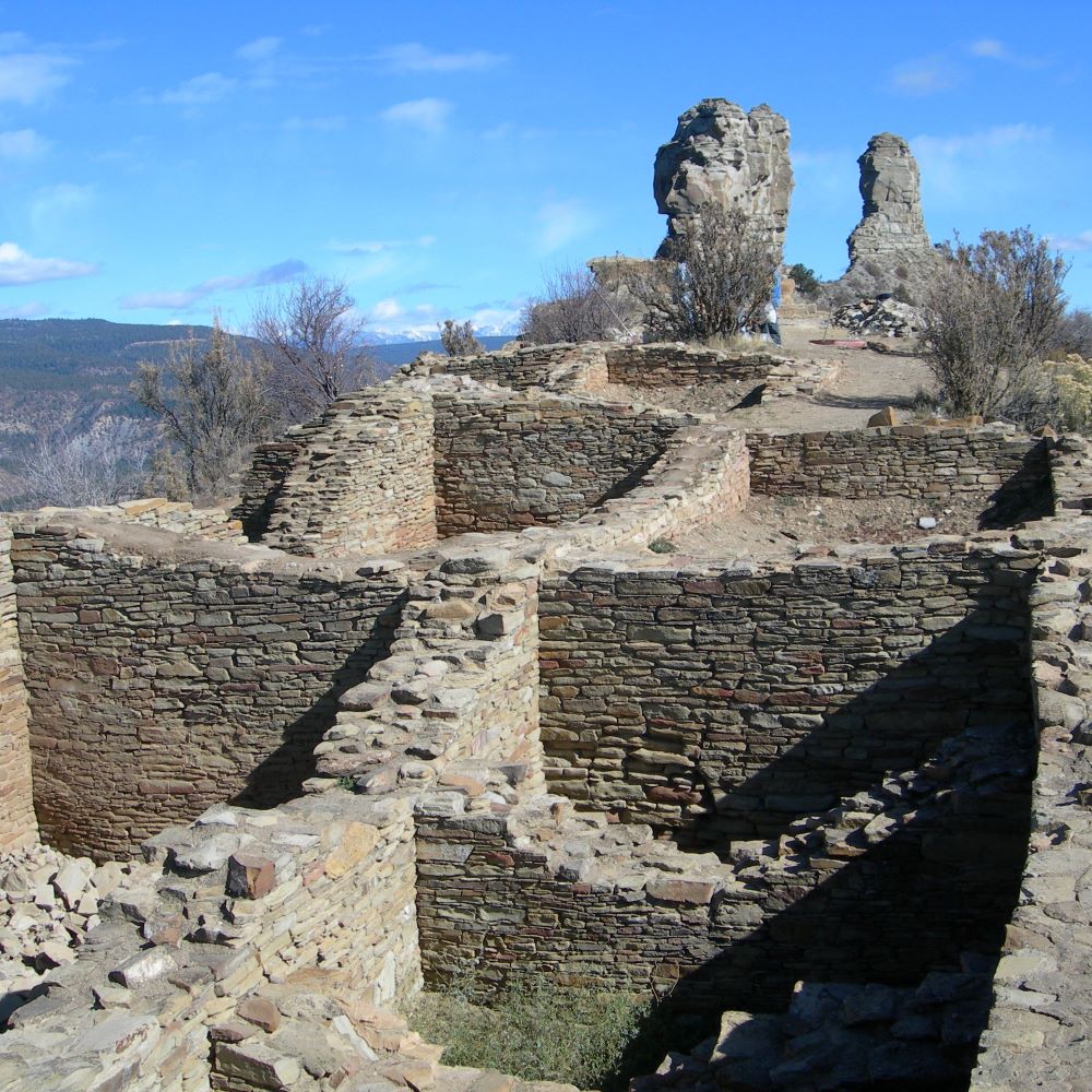
But there is something extraordinary going on that this picture just does not convey.
The Pueblo, Companion Rock, and Chimney Rock are all lined up along a sharp ridge!
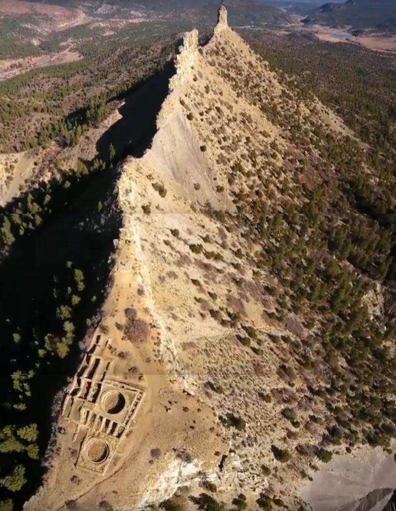
The Pueblo sits on a large plateau that looks down that ridge. Furthermore, as you can see, Chimney and Companion Rocks are not sitting next to each other. They are about 860 feet apart, while the Pueblo is about 2000 feet from Chimney Rock and 1140 feet from Companion Rock.
This is what the ridge actually looks like from the side.
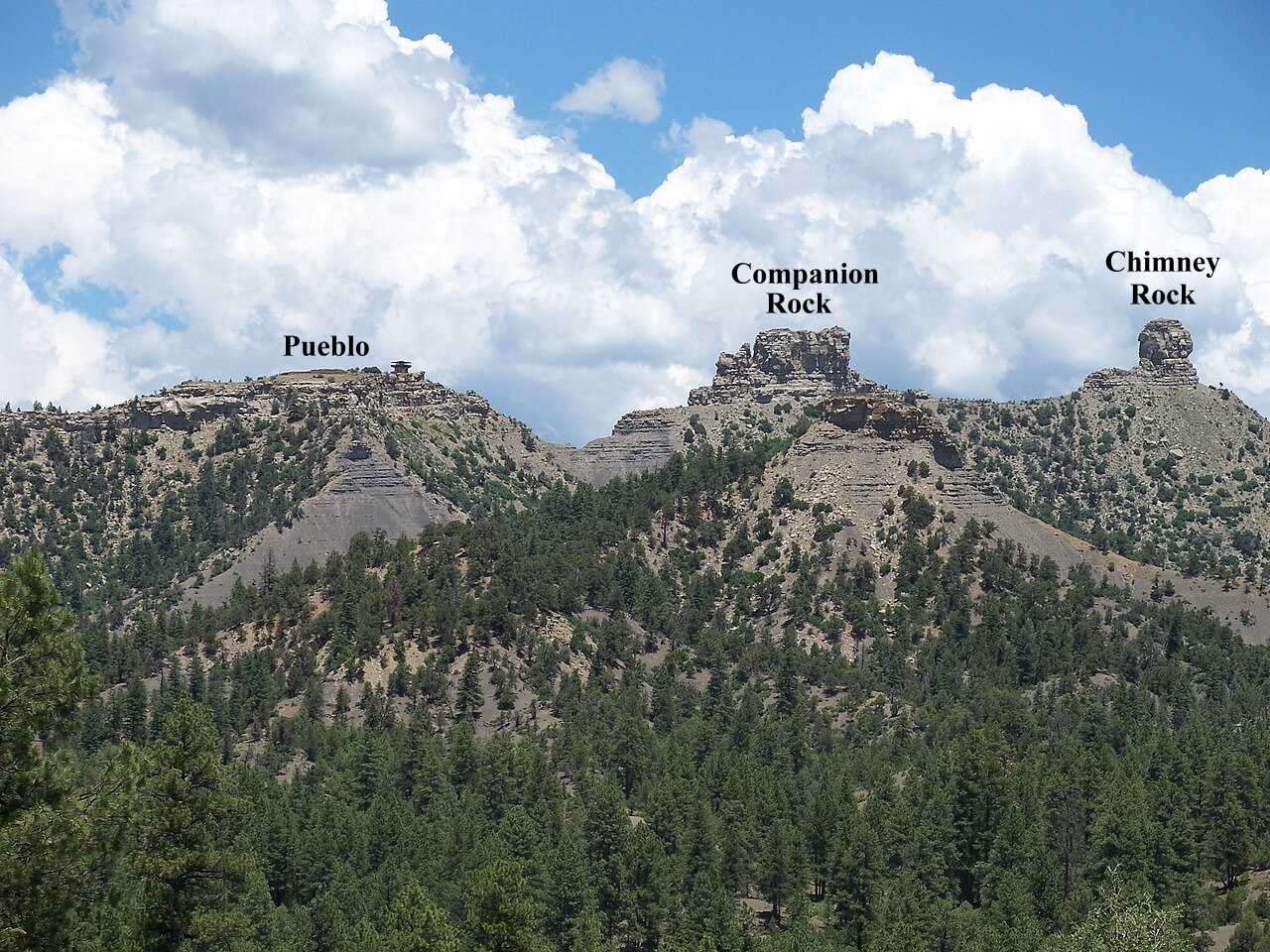
It's hard to realize just how amazing this is. It's not that the two rocks are sitting next to each other, yet they manage to line up to produce that narrow notch. And then the Pueblo Plateau is in the right spot to catch the Major Standstill northernmost lunistice moonrises. To add to that, the notch formed by the two Rocks is at just the right elevation to catch those moonrises.
This is such an extraordinary coincidence.
Yet the Indigenous Peoples managed to notice it. I think this tells us a lot about them. For one thing, it says that they were intimately acquainted with where they lived. They knew their territory and all that was in it. For another, they had to be intimately acquainted with the skies. We cannot know if they first noticed the "mechanics" of the Major Standstill here, or if they knew about them from another location, and then recognized the same mechanics here. It is also hard to fathom just how much this place must have had a sacred (or religious, if you prefer) connection. It must have been incredibly sacred (on top of the already sacred nature of the rest of the land).
We should note that the geography means that only the northernmost moonrises are highlighted at Chimney Rock, not moonsets or anything associated with the Minor Standstill. The angle of the ridge is quite limiting.
Let me add that, while the existence of Chimney Rock is an extraordinary coincidence, this is not an impossible or particularly unreasonable coincidence. After all, the world is vast with endless possibilities. And we must not think that this was the only geological configuration which would have been equally extraordinary in its effect with regards to Major Standstills, while being arranged differently.
Let me switch gears to the Licking Valley.
Southeast of the Great Circle and behind Heath High School sits Salisbury Hill (also know as "Star Hill" because of the Christmas Star that used to be sitting atop it; also known as "Cochrane Hill" from one of the original owners of the property).
Salisbury Hill has a lesser coincidence: It also points to the Major Standstill northernmost lunistice moonrises. If you are paying attention to such things (as the Indigenous Peoples would be doing), it's pretty obvious.
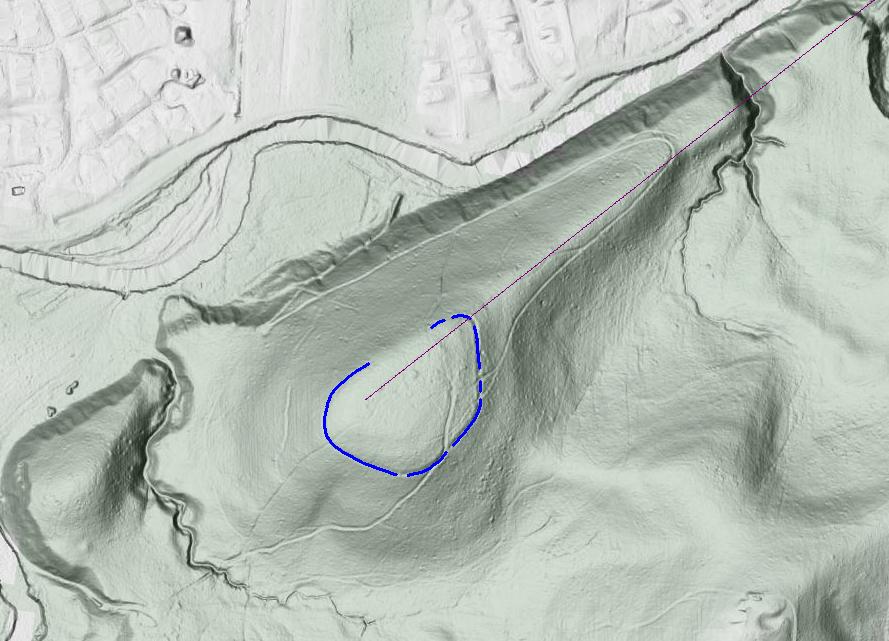
And again, like the Chacoan Peoples, they would have been intimately acquainted with the territory in which they lived, and intimately acquainted with the skies. But if they were watching the Moon and its cycles, there it was.
Salisbury Hill has "Salisbury Hill Fort #1" on top of it. I've drawn that in blue, using the Whittlesey map. This tells us that the Indigenous Peoples of the Hopewell Culture found this an important and sacred spot. This location not only aligns with the Major Standstill, it overlooks the Licking Valley area (and provides a good view of the Great Circle, modulo trees).
But the Licking Valley also has an extraordinary coincidence associated with it, a coincidence on the order of Chimney Rock's.
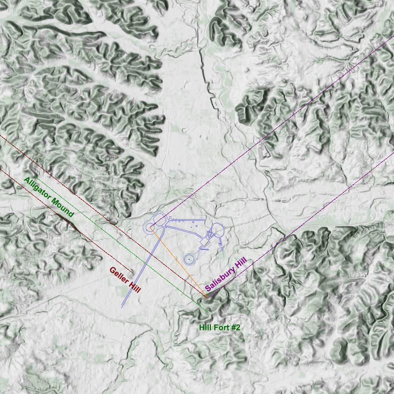
The maroon lines heading off to the northeast point to the Major Standstill northernmost lunistice moonrises. Salisbury Hill was obviously there first. The Octagon's axis points in the same direction. In addition, that orange line is perpendicular to the moonrise lines, suggesting that the placement of Observatory Circle might be recognizing the importance of Salisbury Hill. Interestingly, this orange axis points in the same direction as the axis of the High Bank Octagon down in Chillicothe.
The darker red lines heading off to the northwest point to the Major Standstill northernmost lunistice moonsets. This angle is a reflection of the moonrise lines through a North-South axis (which is what is astronomically expected). What we see is that, using the two prominent landscape locations of Salisbury Hill and Geller Hill as endpoints, they bracket Raccoon Valley.
This is an extraordinary coincidence.
But that is not all. At the end of the bracketing sits Alligator Mound. It is true that Alligator Mound itself has been dated to the Fort Ancient culture, about 800 years ago (around 1200 A.D.). That does not preclude the importance of that location to earlier cultures before Alligator Mound was built. Just look at the way it sticks out there.
At the other end of Alligator Mound along the same dark red moonset axis lies Salisburys' Hill Fort #2, another hill fort, and presumably sacred spot, on the ridge behind Salisbury Hill.
This Hill Fort no longer exists, being covered by a housing development. However, the burial mound there still exists (in some form).
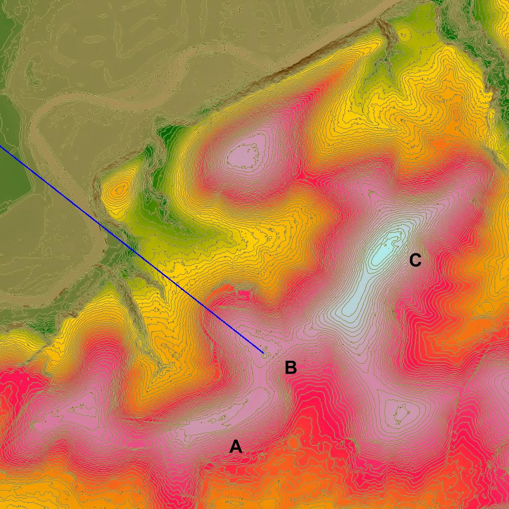
This seems like an odd place for a Hill Fort (actually a ditch and embankment construction surrounding the top of hill—hilltop enclosure is probably a better term). Looking at this topo map (color coded; 4-foot topographic lines), we can see that Hill Fort #2 ("B"), is nestled between two higher hilltops along the ridge ("A" and "C"). Why put a hilltop enclosure there?
This location provides the starting point of the lunistice moonset with a good view of the Alligator Mound's hilltop. This location avoids being blocked the elevations around Salisbury Hill, and aligns with the northernmost lunistice moonset at Alligator Mound Hill.
This suggests that the Indigenous Peoples actually did recognize the extraordinary nature of the Licking Valley, and, just as the Chacoan Peoples did, felt that this place must have embodied a particularly sacred connection to the cosmos. It, too, must have been incredibly sacred (on top of the already sacred nature of the rest of the land).
One issue that must be addressed is that the Licking Valley, unlike Chimney Rock, has a lot of trees. Would the Alligator Mound hill (and the sides of Raccoon Valley) even be visible?
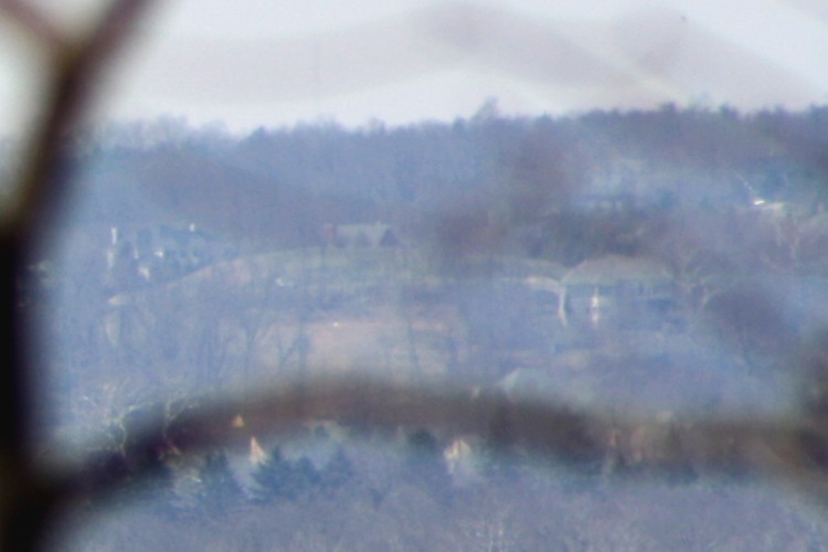
Alligator Mound is visible from Salisbury Hill, even today. (That house is on the back side of the hill.)
There is evidence that the Licking Valley was prairie. Pollen found during an archaeological dig at the Great Circle showed a prairie environment with distant trees, possibly around the hills. But we don't know the extent as to whether that extended up the Raccoon Valley.
That said, it's probably not unreasonable to suggest that they could have seen the direction of the Major Standstill northernmost lunistice moonset from (a possibly-cleared Salisbury Hill) and were familiar enough with where they lived to realize that it extended up Raccoon Valley. They would also likely have been familiar with Raccoon Valley and what was up that way, so they could have done further clearing, atop Alligator Mound Hill at the least.
Just as with Chimney Rock, while this geographical arrangement while the existence of Chimney Rock is an extraordinary coincidence, this is not an impossible or particularly unreasonable coincidence. But it means that the Licking Valley is, in some real sense, the Valley of the Moon, and would have been seen by the Indigenous Peoples as such. Might that larger correspondence have been absorbed by the Indidenous Peoples of the Hopewell Culture and inspired the desire to look deeper and acquire the knowledge necessary to design and build the Octagon aligned to multiple lunistice-related lunar events.
No wonder pilgrimages from across the continent ended here.